| at: |
DeSoto National Forest - South |
Data from USFS GIS
 show on map
 animate
Trail users:


Elevation Profile
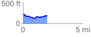
 2.041234 mi
 136.10 ft
 150.94 ft
 -14.84 ft
 1.40 %
GPX Downloads: Track Route
![]()
| at: |
DeSoto National Forest - South |
show on map
animate
2.041234 mi
136.10 ft
150.94 ft
-14.84 ft
1.40 %