|
| at: |
DeSoto National Forest - South |
Data from USFS GIS
 show on map
 animate
Trail users:


Elevation Profile
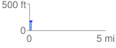
 0.175979 mi
 8.27 ft
 8.27 ft
 0.00 ft
 0.89 %
GPX Downloads: Track Route
![]()
|
| at: |
DeSoto National Forest - South |
show on map
animate
0.175979 mi
8.27 ft
8.27 ft
0.00 ft
0.89 %