|
| at: |
DeSoto National Forest - South |
Data from USFS GIS
 show on map
 animate
Trail users:


Elevation Profile
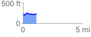
 1.124232 mi
 69.30 ft
 77.38 ft
 -8.08 ft
 1.30 %
GPX Downloads: Track Route
![]()
|
| at: |
DeSoto National Forest - South |
show on map
animate
1.124232 mi
69.30 ft
77.38 ft
-8.08 ft
1.30 %