| at: |
DeSoto National Forest - South |
Data from USFS GIS
 show on map
 animate
Trail users:


Elevation Profile
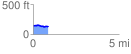
 0.897414 mi
 26.20 ft
 52.98 ft
 -26.78 ft
 1.12 %
GPX Downloads: Track Route
![]()
| at: |
DeSoto National Forest - South |
show on map
animate
0.897414 mi
26.20 ft
52.98 ft
-26.78 ft
1.12 %