| at: |
Bethel Trails DeSoto National Forest - South |
Data from USFS GIS
 show on map
 animate
Trail users:


Elevation Profile
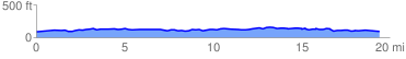
 19.666754 mi
 1280.12 ft
 1280.12 ft
 0.00 ft
 1.23 %
GPX Downloads: Track Route
![]()
| at: |
Bethel Trails DeSoto National Forest - South |
show on map
animate
19.666754 mi
1280.12 ft
1280.12 ft
0.00 ft
1.23 %