| at: |
DeSoto National Forest - South |
Data from USFS GIS
 show on map
 animate
Trail users:


Elevation Profile
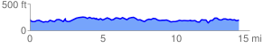
 14.411193 mi
 1815.79 ft
 1813.06 ft
 2.73 ft
 2.39 %
GPX Downloads: Track Route
![]()
| at: |
DeSoto National Forest - South |
show on map
animate
14.411193 mi
1815.79 ft
1813.06 ft
2.73 ft
2.39 %