| at: |
Homochitto National Forest |
Data from USFS GIS
 show on map
 animate
Trail users:


Elevation Profile
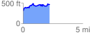
 2.238268 mi
 405.64 ft
 246.00 ft
 159.64 ft
 3.43 %
GPX Downloads: Track Route
![]()
| at: |
Homochitto National Forest |
show on map
animate
2.238268 mi
405.64 ft
246.00 ft
159.64 ft
3.43 %