|
| at: |
Homochitto National Forest |
Data from USFS GIS
 show on map
 animate
Trail users:


Elevation Profile
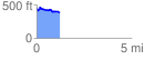
 1.215051 mi
 121.06 ft
 169.08 ft
 -48.02 ft
 2.64 %
GPX Downloads: Track Route
![]()
|
| at: |
Homochitto National Forest |
show on map
animate
1.215051 mi
121.06 ft
169.08 ft
-48.02 ft
2.64 %