|
| at: |
Homochitto National Forest |
Data from USFS GIS
 show on map
 animate
Trail users:


Elevation Profile
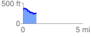
 1.101025 mi
 175.97 ft
 235.73 ft
 -59.76 ft
 4.05 %
GPX Downloads: Track Route
![]()
|
| at: |
Homochitto National Forest |
show on map
animate
1.101025 mi
175.97 ft
235.73 ft
-59.76 ft
4.05 %