|
| at: |
Homochitto National Forest |
Data from USFS GIS
 show on map
 animate
Trail users:


Elevation Profile
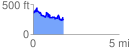
 1.758816 mi
 409.36 ft
 533.15 ft
 -123.78 ft
 5.74 %
GPX Downloads: Track Route
![]()
|
| at: |
Homochitto National Forest |
show on map
animate
1.758816 mi
409.36 ft
533.15 ft
-123.78 ft
5.74 %