| at: |
Homochitto National Forest |
Data from USFS GIS
 show on map
 animate
Trail users:


Elevation Profile
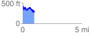
 0.990045 mi
 253.92 ft
 372.31 ft
 -118.40 ft
 7.12 %
GPX Downloads: Track Route
![]()
| at: |
Homochitto National Forest |
show on map
animate
0.990045 mi
253.92 ft
372.31 ft
-118.40 ft
7.12 %