| at: |
Homochitto National Forest |
Data from USFS GIS
 show on map
 animate
Trail users:


Elevation Profile
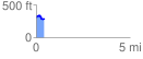
 0.443183 mi
 55.87 ft
 80.70 ft
 -24.83 ft
 3.45 %
GPX Downloads: Track Route
![]()
| at: |
Homochitto National Forest |
show on map
animate
0.443183 mi
55.87 ft
80.70 ft
-24.83 ft
3.45 %