|
| at: |
Homochitto National Forest |
Data from USFS GIS
 show on map
 animate
Trail users:


Elevation Profile
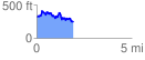
 1.929411 mi
 419.64 ft
 499.77 ft
 -80.13 ft
 4.91 %
GPX Downloads: Track Route
![]()
|
| at: |
Homochitto National Forest |
show on map
animate
1.929411 mi
419.64 ft
499.77 ft
-80.13 ft
4.91 %