|
| at: |
Homochitto National Forest |
Data from USFS GIS
 show on map
 animate
Trail users:


Elevation Profile
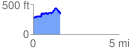
 1.603040 mi
 327.67 ft
 271.74 ft
 55.93 ft
 3.87 %
GPX Downloads: Track Route
![]()
|
| at: |
Homochitto National Forest |
show on map
animate
1.603040 mi
327.67 ft
271.74 ft
55.93 ft
3.87 %