|
| at: |
Homochitto National Forest |
Data from USFS GIS
 show on map
 animate
Trail users:


Elevation Profile
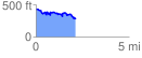
 2.168272 mi
 322.54 ft
 470.20 ft
 -147.66 ft
 4.11 %
GPX Downloads: Track Route
![]()
|
| at: |
Homochitto National Forest |
show on map
animate
2.168272 mi
322.54 ft
470.20 ft
-147.66 ft
4.11 %