|
| at: |
Homochitto National Forest |
Data from USFS GIS
 show on map
 animate
Trail users:


Elevation Profile
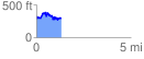
 1.330280 mi
 335.07 ft
 366.62 ft
 -31.55 ft
 5.22 %
GPX Downloads: Track Route
![]()
|
| at: |
Homochitto National Forest |
show on map
animate
1.330280 mi
335.07 ft
366.62 ft
-31.55 ft
5.22 %