|
| at: |
Homochitto National Forest |
Data from USFS GIS
 show on map
 animate
Trail users:


Elevation Profile
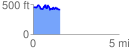
 1.556408 mi
 315.65 ft
 342.19 ft
 -26.53 ft
 4.16 %
GPX Downloads: Track Route
![]()
|
| at: |
Homochitto National Forest |
show on map
animate
1.556408 mi
315.65 ft
342.19 ft
-26.53 ft
4.16 %