| at: |
Homochitto National Forest |
Data from USFS GIS
 show on map
 animate
Trail users:


Elevation Profile
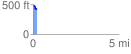
 0.204450 mi
 2.30 ft
 85.93 ft
 -83.63 ft
 7.96 %
GPX Downloads: Track Route
![]()
| at: |
Homochitto National Forest |
show on map
animate
0.204450 mi
2.30 ft
85.93 ft
-83.63 ft
7.96 %