| at: |
Homochitto National Forest |
Data from USFS GIS
 show on map
 animate
Trail users:


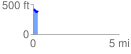
Elevation Profile
 0.267675 mi
 54.99 ft
 67.07 ft
 -12.08 ft
 4.75 %
GPX Downloads: Track Route
![]()
| at: |
Homochitto National Forest |
show on map
animate
0.267675 mi
54.99 ft
67.07 ft
-12.08 ft
4.75 %