|
| at: |
Homochitto National Forest |
Data from USFS GIS
 show on map
 animate
Trail users:


Elevation Profile
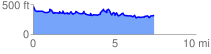
 7.483494 mi
 1175.53 ft
 1297.72 ft
 -122.19 ft
 3.28 %
GPX Downloads: Track Route
![]()
|
| at: |
Homochitto National Forest |
show on map
animate
7.483494 mi
1175.53 ft
1297.72 ft
-122.19 ft
3.28 %