| at: |
Homochitto National Forest |
Data from USFS GIS
 show on map
 animate
Trail users:


Elevation Profile
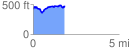
 1.835692 mi
 301.12 ft
 245.01 ft
 56.11 ft
 3.11 %
GPX Downloads: Track Route
![]()
| at: |
Homochitto National Forest |
show on map
animate
1.835692 mi
301.12 ft
245.01 ft
56.11 ft
3.11 %