|
| at: |
Homochitto National Forest |
Data from USFS GIS
 show on map
 animate
Trail users:


Elevation Profile
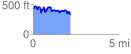
 2.169025 mi
 448.17 ft
 576.20 ft
 -128.03 ft
 5.03 %
GPX Downloads: Track Route
![]()
|
| at: |
Homochitto National Forest |
show on map
animate
2.169025 mi
448.17 ft
576.20 ft
-128.03 ft
5.03 %