|
| at: |
Homochitto National Forest |
Data from USFS GIS
 show on map
 animate
Trail users:


Elevation Profile
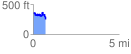
 0.727477 mi
 151.46 ft
 251.02 ft
 -99.56 ft
 6.54 %
GPX Downloads: Track Route
![]()
|
| at: |
Homochitto National Forest |
show on map
animate
0.727477 mi
151.46 ft
251.02 ft
-99.56 ft
6.54 %