| at: |
Homochitto National Forest |
Data from USFS GIS
 show on map
 animate
Trail users:


Elevation Profile
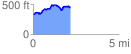
 2.175306 mi
 343.41 ft
 253.22 ft
 90.18 ft
 2.99 %
GPX Downloads: Track Route
![]()
| at: |
Homochitto National Forest |
show on map
animate
2.175306 mi
343.41 ft
253.22 ft
90.18 ft
2.99 %