| at: |
Homochitto National Forest |
Data from USFS GIS
 show on map
 animate
Trail users:


Elevation Profile
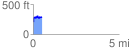
 0.507002 mi
 138.38 ft
 53.28 ft
 85.10 ft
 5.17 %
GPX Downloads: Track Route
![]()
| at: |
Homochitto National Forest |
show on map
animate
0.507002 mi
138.38 ft
53.28 ft
85.10 ft
5.17 %