|
| at: |
Homochitto National Forest |
Data from USFS GIS
 show on map
 animate
Trail users:


Elevation Profile
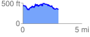
 3.029593 mi
 626.41 ft
 699.67 ft
 -73.26 ft
 4.37 %
GPX Downloads: Track Route
![]()
|
| at: |
Homochitto National Forest |
show on map
animate
3.029593 mi
626.41 ft
699.67 ft
-73.26 ft
4.37 %