|
| at: |
Homochitto National Forest |
Data from USFS GIS
 show on map
 animate
Trail users:


Elevation Profile
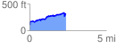
 2.359594 mi
 453.45 ft
 243.87 ft
 209.58 ft
 3.64 %
GPX Downloads: Track Route
![]()
|
| at: |
Homochitto National Forest |
show on map
animate
2.359594 mi
453.45 ft
243.87 ft
209.58 ft
3.64 %