|
| at: |
Homochitto National Forest |
Data from USFS GIS
 show on map
 animate
Trail users:


Elevation Profile
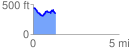
 1.315852 mi
 187.75 ft
 275.85 ft
 -88.10 ft
 3.97 %
GPX Downloads: Track Route
![]()
|
| at: |
Homochitto National Forest |
show on map
animate
1.315852 mi
187.75 ft
275.85 ft
-88.10 ft
3.97 %