| at: |
Homochitto National Forest |
Data from USFS GIS
 show on map
 animate
Trail users:


Elevation Profile
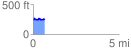
 0.670108 mi
 86.97 ft
 68.62 ft
 18.35 ft
 2.46 %
GPX Downloads: Track Route
![]()
| at: |
Homochitto National Forest |
show on map
animate
0.670108 mi
86.97 ft
68.62 ft
18.35 ft
2.46 %