|
| at: |
Homochitto National Forest |
Data from USFS GIS
 show on map
 animate
Trail users:


Elevation Profile
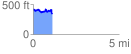
 1.125912 mi
 153.30 ft
 227.53 ft
 -74.23 ft
 3.83 %
GPX Downloads: Track Route
![]()
|
| at: |
Homochitto National Forest |
show on map
animate
1.125912 mi
153.30 ft
227.53 ft
-74.23 ft
3.83 %