|
| at: |
Homochitto National Forest |
Data from USFS GIS
 show on map
 animate
Trail users:


Elevation Profile
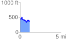
 1.193441 mi
 233.77 ft
 298.59 ft
 -64.82 ft
 4.74 %
GPX Downloads: Track Route
![]()
|
| at: |
Homochitto National Forest |
show on map
animate
1.193441 mi
233.77 ft
298.59 ft
-64.82 ft
4.74 %