| at: |
Homochitto National Forest |
Data from USFS GIS
 show on map
 animate
Trail users:


Elevation Profile
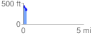
 0.283904 mi
 102.87 ft
 117.24 ft
 -14.37 ft
 7.82 %
GPX Downloads: Track Route
![]()
| at: |
Homochitto National Forest |
show on map
animate
0.283904 mi
102.87 ft
117.24 ft
-14.37 ft
7.82 %