| at: |
Homochitto National Forest |
Data from USFS GIS
 show on map
 animate
Trail users:


Elevation Profile
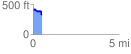
 0.505094 mi
 55.09 ft
 113.58 ft
 -58.49 ft
 4.26 %
GPX Downloads: Track Route
![]()
| at: |
Homochitto National Forest |
show on map
animate
0.505094 mi
55.09 ft
113.58 ft
-58.49 ft
4.26 %