| at: |
Homochitto National Forest |
Data from USFS GIS
 show on map
 animate
Trail users:


Elevation Profile
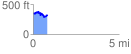
 0.828686 mi
 169.54 ft
 183.13 ft
 -13.59 ft
 4.19 %
GPX Downloads: Track Route
![]()
| at: |
Homochitto National Forest |
show on map
animate
0.828686 mi
169.54 ft
183.13 ft
-13.59 ft
4.19 %