|
| at: |
Homochitto National Forest |
Data from USFS GIS
 show on map
 animate
Trail users:


Elevation Profile
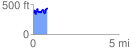
 0.848353 mi
 277.81 ft
 202.54 ft
 75.27 ft
 6.20 %
GPX Downloads: Track Route
![]()
|
| at: |
Homochitto National Forest |
show on map
animate
0.848353 mi
277.81 ft
202.54 ft
75.27 ft
6.20 %