| at: |
Homochitto National Forest |
Data from USFS GIS
 show on map
 animate
Trail users:


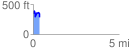
Elevation Profile
 0.398736 mi
 119.64 ft
 178.71 ft
 -59.07 ft
 8.49 %
GPX Downloads: Track Route
![]()
| at: |
Homochitto National Forest |
show on map
animate
0.398736 mi
119.64 ft
178.71 ft
-59.07 ft
8.49 %