|
| at: |
Homochitto National Forest |
Data from USFS GIS
 show on map
 animate
Trail users:


Elevation Profile
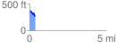
 0.354093 mi
 38.61 ft
 117.74 ft
 -79.13 ft
 6.30 %
GPX Downloads: Track Route
![]()
|
| at: |
Homochitto National Forest |
show on map
animate
0.354093 mi
38.61 ft
117.74 ft
-79.13 ft
6.30 %