|
| at: |
Homochitto National Forest |
Data from USFS GIS
 show on map
 animate
Trail users:


Elevation Profile
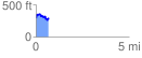
 0.695931 mi
 145.35 ft
 161.31 ft
 -15.97 ft
 4.39 %
GPX Downloads: Track Route
![]()
|
| at: |
Homochitto National Forest |
show on map
animate
0.695931 mi
145.35 ft
161.31 ft
-15.97 ft
4.39 %