| at: |
Homochitto National Forest |
Data from USFS GIS
 show on map
 animate
Trail users:


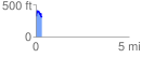
Elevation Profile
 0.306318 mi
 93.86 ft
 112.36 ft
 -18.51 ft
 6.95 %
GPX Downloads: Track Route
![]()
| at: |
Homochitto National Forest |
show on map
animate
0.306318 mi
93.86 ft
112.36 ft
-18.51 ft
6.95 %