|
| at: |
Homochitto National Forest |
Data from USFS GIS
 show on map
 animate
Trail users:


Elevation Profile
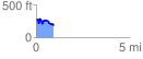
 0.927354 mi
 167.27 ft
 238.42 ft
 -71.15 ft
 4.87 %
GPX Downloads: Track Route
![]()
|
| at: |
Homochitto National Forest |
show on map
animate
0.927354 mi
167.27 ft
238.42 ft
-71.15 ft
4.87 %