|
| at: |
Homochitto National Forest |
Data from USFS GIS
 show on map
 animate
Trail users:


Elevation Profile
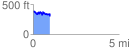
 0.988723 mi
 149.70 ft
 226.94 ft
 -77.24 ft
 4.35 %
GPX Downloads: Track Route
![]()
|
| at: |
Homochitto National Forest |
show on map
animate
0.988723 mi
149.70 ft
226.94 ft
-77.24 ft
4.35 %