|
| at: |
Homochitto National Forest |
Data from USFS GIS
 show on map
 animate
Trail users:


Elevation Profile
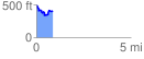
 0.874116 mi
 126.14 ft
 208.96 ft
 -82.82 ft
 4.53 %
GPX Downloads: Track Route
![]()
|
| at: |
Homochitto National Forest |
show on map
animate
0.874116 mi
126.14 ft
208.96 ft
-82.82 ft
4.53 %