| at: |
Homochitto National Forest |
Data from USFS GIS
 show on map
 animate
Trail users:


Elevation Profile
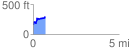
 0.703773 mi
 193.40 ft
 78.02 ft
 115.38 ft
 5.20 %
GPX Downloads: Track Route
![]()
| at: |
Homochitto National Forest |
show on map
animate
0.703773 mi
193.40 ft
78.02 ft
115.38 ft
5.20 %