| at: |
Homochitto National Forest |
Data from USFS GIS
 show on map
 animate
Trail users:


Elevation Profile
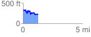
 1.270857 mi
 168.45 ft
 262.32 ft
 -93.88 ft
 3.91 %
GPX Downloads: Track Route
![]()
| at: |
Homochitto National Forest |
show on map
animate
1.270857 mi
168.45 ft
262.32 ft
-93.88 ft
3.91 %