| at: |
Homochitto National Forest |
Data from USFS GIS
 show on map
 animate
Trail users:


Elevation Profile
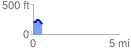
 0.526961 mi
 99.05 ft
 146.62 ft
 -47.57 ft
 5.27 %
GPX Downloads: Track Route
![]()
| at: |
Homochitto National Forest |
show on map
animate
0.526961 mi
99.05 ft
146.62 ft
-47.57 ft
5.27 %