| at: |
Homochitto National Forest |
Data from USFS GIS
 show on map
 animate
Trail users:


Elevation Profile
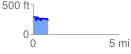
 0.857001 mi
 132.36 ft
 196.54 ft
 -64.18 ft
 4.34 %
GPX Downloads: Track Route
![]()
| at: |
Homochitto National Forest |
show on map
animate
0.857001 mi
132.36 ft
196.54 ft
-64.18 ft
4.34 %