|
| at: |
Homochitto National Forest |
Data from USFS GIS
 show on map
 animate
Trail users:


Elevation Profile
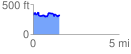
 1.537802 mi
 282.04 ft
 290.41 ft
 -8.37 ft
 3.58 %
GPX Downloads: Track Route
![]()
|
| at: |
Homochitto National Forest |
show on map
animate
1.537802 mi
282.04 ft
290.41 ft
-8.37 ft
3.58 %