|
| at: |
Blue Ridge WMA |
Data from David Muse
 show on map
 animate
Trail users:


Elevation Profile
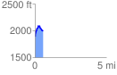
 0.562192 mi
 212.17 ft
 95.67 ft
 116.50 ft
 7.15 %
GPX Downloads: Track Route
![]()
|
| at: |
Blue Ridge WMA |
show on map
animate
0.562192 mi
212.17 ft
95.67 ft
116.50 ft
7.15 %