| at: |
Blue Ridge WMA |
Data from David Muse
 show on map
 animate
Trail users:


Elevation Profile
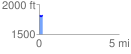
 0.230048 mi
 20.76 ft
 17.67 ft
 3.09 ft
 1.71 %
GPX Downloads: Track Route
![]()
| at: |
Blue Ridge WMA |
show on map
animate
0.230048 mi
20.76 ft
17.67 ft
3.09 ft
1.71 %