|
| at: |
Blue Ridge WMA |
Data from David Muse
 show on map
 animate
Trail users:


Elevation Profile
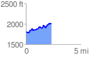
 2.310571 mi
 419.00 ft
 218.71 ft
 200.28 ft
 3.43 %
GPX Downloads: Track Route
![]()
|
| at: |
Blue Ridge WMA |
show on map
animate
2.310571 mi
419.00 ft
218.71 ft
200.28 ft
3.43 %